
Target the species you want
Track all your FADs
Be recommended & supported
by worlwide ocean experts
CATSAT v6.0 is now available. The New Generation of CATSAT service for Pelagic Fishermen offers significant improvements to support: Anticipation, Performance and Selectivity.
CATSAT Team has developed fresh, intuitive, customized software & services with an all-new design. CATSAT v6.0 comes with the best oceanographic data available in the fishing market, offering Captains the best maps to locate oceanic frontal structures with precision.
Our company, as data provider of Copernicus project (European Information services based on satellite Earth Observation and in situ data), acquires and processes raw data, which guarantees best treatment processes and optimized products oriented to fishing in CATSAT.
Our remote sensing data teams, as Copernicus providers, are involved in many actual and future satellite data international projects, guaranteeing optimal oceanographic data quality for CATSAT now, and in the future.
Anticipation: Enhance your operation at sea

Oceanographic data forecast
Captains are now able to anticipate 3 days in advance the tendency of Sub-Surface Temperature, Thermocline and Global Current products with CATSAT v6.0 daily forecast maps.
You have now access to the highest resolution sub-surface oceanography forecast maps in the market, with a 10 Km resolution. Ideal for fishermen targeting sub-surface layers such as longliners, pelagic trawlers or even purse seiners.
Safer operation at sea thanks to meteorological data diversification
-
MULTI-PROVIDER
Because there is not a unique ideal worldwide meteorological provider, CATSAT v6.0 offers daily weather forecasts from the European Centre for Medium-Range Weather Forecasts (ECMWF) and the National Centers for Environmental Predictions (NCEP) providers.
The Captain has both data available to compare in situ conditions and relies in the best forecast.

 HIGHER RESOLUTION
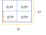
CATSAT meteorological data jumps from 1º in CATSAT v5 to 0.5º resolution in CATSAT v6.0 for both providers (ECMWF & NCEP). This means 4x more resolution (see ex. on the right).
-
A NEW FRESHNESS FOR YOUR DATA
Model’s runs to calculate Meteorological forecasts are doubled to obtain more fresh weather forecasts (runs at 0:00 and 12:00 UTC).
Follow fleet movements thanks to AIS data
Thanks to CATSAT v6.0, user’s vessel positions from satellite AIS information are at your fingertips. Captains are able to create their list of favorite vessels to filter out the unwanted. A key information for Captains to anticipate fleet movements.

Performance: Tracking your FADs

Control your FADs
Identify ideal spots
The Drift Tool offers a drift forecast for all your FADs in the water permanently and helps you identify ideal spots to place your FADs in the water.
A customized approach spatio-temporally designed
CATSAT v6.0 Drift Tool calculates an authentic drift forecast. It considers your FADs as 3D vertical floating objects, and uses forecast data of wind, surface currents and sub-surface currents in a way adapted to the oceanographic vertical layer structure of each fishing area & season.
A customized service
The CATSAT Drift Tool can be adjusted to each company FAD structure to boost the precision of your drift forecasts.

Performance: Fishing
Derived from a Lower and Mid-Trophic Level predictive model, CATSAT v6.0 starts a new line of habitat maps aiming to help fishermen increase the fishing performance towards target species.

Zooplankton Maps
CATSAT goes one step beyond phytoplankton concentration in the trophic chain with zooplankton biomass estimation maps.
Captains are able to identify with zooplankton maps, potential zones for which small pelagic species shall be attracted, ideal for fisheries targeting small pelagic fish species, such as pelagic trawlers.

Micronekton Maps
CATSAT v6.0 offers 4 different maps of micronekton biomass estimation based in pelagic species vertical behavior in the water column.
In a higher trophic layer than zooplankton, micronekton maps help Captains identify potential fishing grounds for small pelagic and top predators (tunas, swordfish,…).

Selectivity: Increase efficiency with target species
Derived from a predator predictive model, CATSAT v6.0 launches a new line of tactical data called Habitat Maps, aiming to help fishermen increase selectivity towards target species. There are 2 different habitat maps available weekly:
- Preferred Adult Skipjack Tuna (SKJ) Habitat Map
- Juvenile Bigeye Tuna (BET) Risk Habitat Map
SKJ Habitat maps forecast preferred areas to which Adult Skipjack shall be attracted. SKJ maps could also be used by tropical purse seine Captains as a complement to CATSAT FAD drift tool.
The Juvenile BET Risk Habitat weekly map forecast areas with higher risk conditions for juvenile BET Tuna presence. Given that BET population is not in good shape in some regions according to different RFMOS, with Habitat Maps, CATSAT v6.0 aims to offer Captains tools to be able to prioritize FADs in areas with ideal conditions for Adult SKJ and to reduce catches of juvenile BET.

News on data sets
There are great new products planned for future CATSAT versions. Therefore, a thought process has been carried out to find a balance between providing you with the best service but also with the most relevant data.
More data does not always mean better, when dealing with satcom systems.
With the objective of providing you with a balanced offer of products, the CATSAT team has decided to stop several products starting 17th May 2021. In the table on the left are the reasons why.